Online Booking
Once-in-40-Years Winter Storm Sweeps Across the U.S. Logistics and Transportation Face Widespread Delays
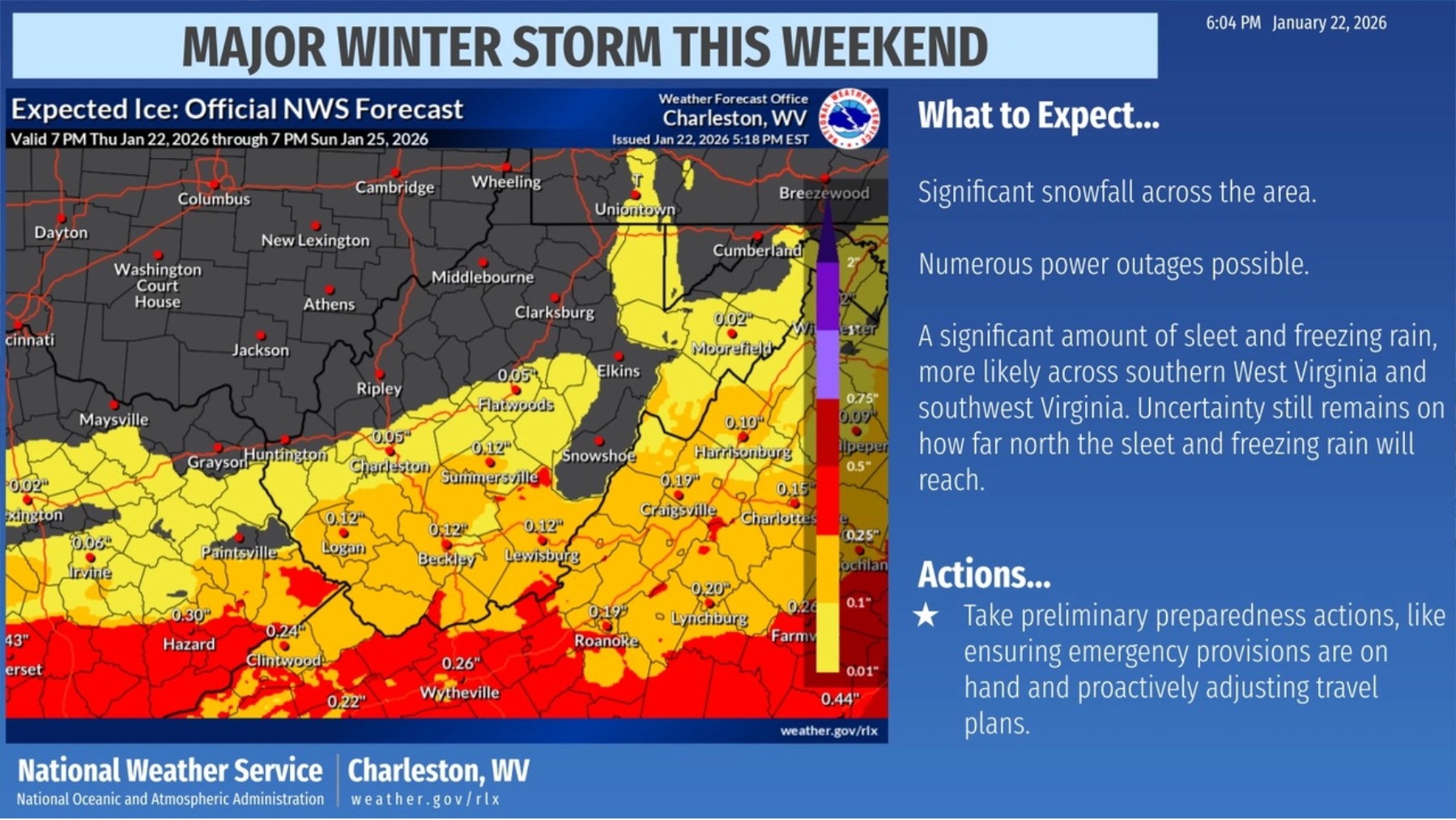
Image source: US National Weather Service (NWS), Charleston, WV
The United States is currently facing one of the most severe winter storms in nearly four decades, affecting dozens of states. According to U.S. weather authorities, an Arctic air mass originating from Canada is rapidly moving south and merging with a cold-weather system known as Storm Fern, bringing record-breaking low temperatures, heavy snow, freezing rain, and an increased risk of widespread power outages across large parts of the country.
Widespread Impact Affecting Nearly Half of the U.S. Population
Meteorological agencies forecast that this large-scale winter storm will impact nearly half of the U.S. population. Beginning January 23, an estimated 150 million people may experience disruptions to travel and daily activities.
Snowfall in parts of the U.S. East Coast is expected to exceed one foot (approximately 30 cm). From Texas to Georgia, many areas are likely to face freezing rain and ice accumulation, resulting in hazardous road conditions and increased strain on public infrastructure.
Jonathan Porter, Chief Meteorologist at AccuWeather, stated:
“This is a major storm. In our view, it is likely the most severe storm so far this winter and potentially one of the most widespread winter storms the U.S. has experienced in the past decade.”
Extreme Cold and Heavy Snow Expanding Northward
As the storm system continues to move north, the Northeastern United States is expected to experience extreme cold conditions. The Arctic blast is forecast to move from New Mexico through Oklahoma and Kansas, then eastward into the Ohio Valley, bringing widespread heavy snowfall and dangerous ice accumulation.
In some areas, wind chill values could drop to as low as –50°F (–46°C), posing serious risks to outdoor activities, power supply stability, and public safety.
Snow Accumulation Reaching Warning Levels
Weather authorities estimate that:
-
Some regions may receive 6–12 inches of snow
-
New York City could see 4–8 inches of snowfall
-
Baltimore, Washington D.C., and surrounding areas may receive 6–10 inches
Major Logistics Hubs Across Multiple States Impacted
This winter storm is affecting several key U.S. logistics corridors and hubs. The most impacted regions include:
-
Central and South-Central U.S. (primarily heavy snow): Colorado (CO), Kansas (KS), Oklahoma (OK), Missouri (MO), Arkansas (AR), Tennessee (TN), Kentucky (KY)
-
Southeastern U.S. (high freezing rain risk): Mississippi (MS), Alabama (AL), Georgia (GA), South Carolina (SC), North Carolina (NC)
-
Mid-Atlantic and Northeastern U.S. (snow and freezing rain combination): Virginia (VA), West Virginia (WV), Maryland (MD), Pennsylvania (PA), New Jersey (NJ), New York (NY), Connecticut (CT), Massachusetts (MA), and parts of New England
Port Operations and Inland Transportation Under Pressure
At ports, severe weather conditions have led to congestion, suspended container releases, and temporary terminal closures. Major ports such as Houston (HOU) and Savannah (SAV) are among those affected. During terminal closures, container pick-up and return operations are not permitted. Recovery timelines will depend on weather developments and official port announcements.
Inland transportation and last-mile delivery services are also experiencing delays due to snow-covered and icy roads. Delivery times in affected areas are expected to be extended, with longer delays possible in remote regions. In addition, long-haul interregional trucking operations are facing disruptions, resulting in reduced capacity and slower overall logistics turnover.
Severe Challenges for Air and Road Transportation
Several major interstate highways may be closed due to snow and ice accumulation, making travel conditions extremely difficult and dangerous.
Major aviation hubs, including Dallas and Atlanta, are expected to face significant operational disruptions. Industry forecasts indicate that flight cancellations over the coming days could reach 6,000 flights or more, further affecting passenger movement and air cargo operations.
We will continue to closely monitor weather conditions and logistics recovery progress and share the latest updates as soon as they become available. Thank you for your understanding and cooperation.